| 728 | Cedars of Lebanon State Park New Map |
2012-11-10 |
On Thursday, Nov 08, we finished the new map for Cedars of Lebanon State Park. Each map we make on cloudhiking.com is different and special to us. We celebrate each finished one, announce it on Metro to Mountain, and then immediately begin thinking about the next.
So for a few map notes from Cedars of Lebanon ...
The Park is in a cedar glade. Long Hunter State Park and Barfield Crescent Park - Wilderness Station are also in cedar glades.
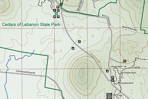
There are many sink holes in the Park. We tried to use tic marks on the contours to show the depressions, but some of the holes were very small. For the smaller holes we used a lighter shade of coloring to help with the distinction. The sink holes are one of the most distinguishing features of the Park.
Five trails, Hidden Springs, Cedar Forest, Cedar Glade, Dixon Marritt, and Limestone Sinks, are shown on the map.
The USGS map uses a 10 foot contour interval, we used a 20 foot interval instead. To be honest, there is not a lot of elevation changes in the Park.
The Hidden Springs Trail was the longest. The Park signs indicated the trail was 5 miles, but the GPS, with several readings, indicate the trail is only 4.4 miles. Exact mileages can be very tricky to determine. The fact that the two mileages are different is just par for the course. We are using our GPS readings on the map because they should match the mileages other hikers receive while using their GPS units. You can still say the trail is 5 miles, but if you look at your GPS - it will probably only be 4.4 miles!
We also updated the Adventure Guides to the Hidden Springs Trail and the Cedar Forest Trail. The Cedars of Lebanon Park map is linked from both of the guides.
The map shows waypoints which we think are recognizable. Consult the Adventure Guides of the trails for pictures of the waypoints.
The trails are rated as easy.
Visit the Park and enjoy the trails.
Happy Cedars Map trails
cloudhiking links - Cedars of Lebanon Map, Hidden Springs Trail, Cedar Forest Trail